 On Friday, US Environmental Protection Agency (EPA) Administrator Gina McCarthy will join community members at Newark, New Jersey’s Ironbound Neighborhood Family Success Center (East) to launch a new community air monitor, a first of its kind citizen science project. Administrator McCarthy will discuss the agency’s work on air quality and how citizen science plays an important role in scientific analysis.
Fri 13 March 2015 @ 10:15 am
Ironbound Community Corporation (ICC)
Family Success Center – East
29 Cortland Street
Newark, NJ 07105
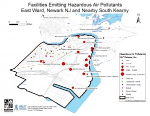
In 2010, A collaboration between Drew University and the ICC used GIS mapping technology to prove the need for air quality control in Newark. With support from an EPA CARE grant, student Zoe Crum mapped data the ICC helped gather to show, “industrial chemical emissions, Brownfield sites, and Superfund sites in conjunction with demographic analyses for the Ironbound.”
Twenty-five percent of Newark children suffer from asthma, three times the state average, and asthma accounts for the leading cause of absenteeism for Newark’s school age children. Accurate and timely information on air pollution is critical to protecting public health. With data in hand, residents have a better chance of taking effective action to keep themselves and their families safe and healthy.